2025 Atlantic Hurricane Season: Tracking Storms & Forecasts
The 2025 Atlantic Hurricane Season is already shaping up to be a busy one, with the National Hurricane Center (NHC) closely monitoring every tropical disturbance that forms. From tropical depressions to early‑stage hurricanes, scientists use a blend of satellite imagery, radar data, and computer models to keep track of each system’s path, intensity, and potential impact. For residents along the coast and anyone curious about the storm cycle, understanding how these storms are tracked can help with preparation and safety decisions.
Tracking Storms in the 2025 Atlantic Season
Tracking storms is a dynamic process that starts when a low‑pressure area forms over the tropical Atlantic. The NHC assigns a number to each new system once it meets specific criteria: organized convection, closed circulation, and a sustained wind speed of at least 20 mph. From there, forecasters use a suite of tools to predict how the storm will evolve.
How the National Hurricane Center Tracks Systems
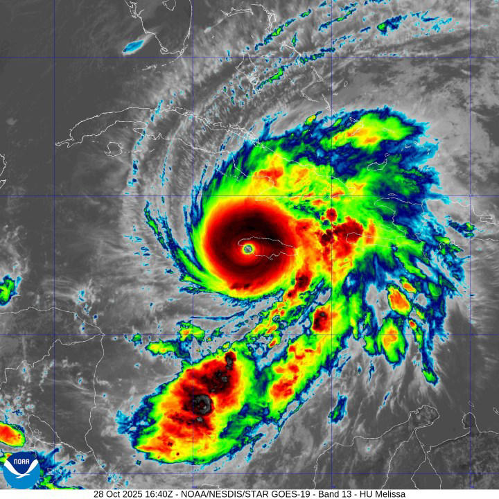
- Satellite imagery: Geostationary satellites provide continuous images of cloud patterns and wind fields.
- Scatterometer wind scans: These radar‑based instruments measure surface wind speeds over the ocean.
- Reconnaissance aircraft: The “Hurricane Hunters” fly into storms to collect wind, pressure, and temperature data directly.
- Numerical models: The NHC runs several high‑resolution models—such as the GFS, ECMWF, and HWRF—to generate track and intensity forecasts.
- Data assimilation: Observations are fed into models in real time to keep predictions as accurate as possible.
Key Tools and Data for Meteorologists
- Best track data: Post‑season analyses refine the final recorded path and intensity of each storm.
- Probabilistic maps: The NHC releases 1‑day, 3‑day, and 5‑day probability maps to illustrate where a storm may take a chance of making landfall.
- Intensity forecasts: The 1‑, 3‑, and 5‑day forecasts give the expected maximum sustained winds and central pressure.
- Ensemble forecasting: Multiple runs of the same model provide a spread of possible outcomes, helping to gauge uncertainty.
Public Resources for Real-Time Updates
- NHC website: Offers the latest advisory bulletins, outlooks, and interactive maps.
- NOAA Weather Radio: Broadcasts warnings and updates in real time for local communities.
- Weather apps and social media: Official NHC feeds on Twitter and Facebook provide quick alerts and educational content.
- Local media: Radio and TV stations often partner with the NHC for specialized coverage during peak activity.
Current Storms to Watch in 2025
By mid‑March, the Atlantic has already produced two tropical depressions that have shown significant development potential. While these systems are still in their early stages, their trajectories will determine which regions might face the brunt of the season.
Tropical Depression One
Forming near the Cape Verde Islands, this low‑pressure area has a well‑defined circulation but remains below tropical storm intensity. Forecast models suggest a gradual intensification over the next week, potentially reaching hurricane strength if sea‑surface temperatures remain warm and wind shear stays low.
Tropical Depression Two
Located in the central Atlantic, this system has encountered higher wind shear, limiting its organization. Nevertheless, its path could take it towards the Lesser Antilles, where it could cause significant rainfall and wind gusts, especially if it stalls over the islands.
Forecasting Trends and What They Mean for Residents
Seasonal outlooks are updated quarterly, incorporating the latest climatological data and model trends. For 2025, the NHC’s latest forecast indicates a slightly above‑average number of named storms, with a moderate probability of two or more hurricanes making landfall along the U.S. East Coast.
Probability Maps and Seasonal Outlooks
The NHC’s 2025 outlook provides a 33‑day forecast that identifies the most likely tracks for each potential hurricane. These maps are color‑coded: green indicates a low probability of landfall, yellow shows a moderate chance, and red signals a high likelihood. Residents in the highlighted zones should monitor the maps regularly as the season progresses.
Preparing for Possible Impacts
- Secure outdoor items: Winds of up to 120 mph can uproot trees and damage property.
- Create an emergency kit: Include water, non‑perishable food, flashlight, batteries, and a first‑aid kit.
- Know evacuation routes: Familiarize yourself with local emergency plans and shelters.
- Stay informed: Subscribe to local alerts and keep your phone charged during storm warnings.
FAQ About Tracking the Atlantic Hurricane Season
What is the difference between a tropical depression and a hurricane?